At OAR, we deliver high-accuracy laser scanning in New Hampshire to help project teams design, build, and manage with confidence. From industrial plants to schools, our 3D laser scanning workflows turn real-world spaces into precise, measurable digital models — eliminating guesswork and reducing costly rework.

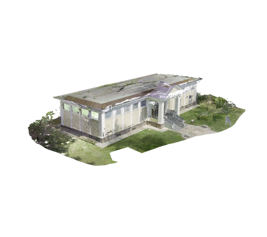
Laser scanning is a precise method of digitally measuring and documenting real-world spaces using advanced laser instruments. By capturing millions of points in seconds, OAR produces a 3D point cloud — an exact digital replica of your building, site, or structure.
Instead of relying on outdated drawings or field sketches, your team works with verified as-built data to make better design, coordination, and construction decisions.
We use industry-leading laser scanners to capture interiors, exteriors, and tight spaces with sub-millimeter accuracy.
Drone and elevated scanning capture rooftops, facades, and hard-to-access areas for complete coverage.
All scans are processed, cleaned, and aligned to control points, producing geo-referenced datasets ready for design and analysis.
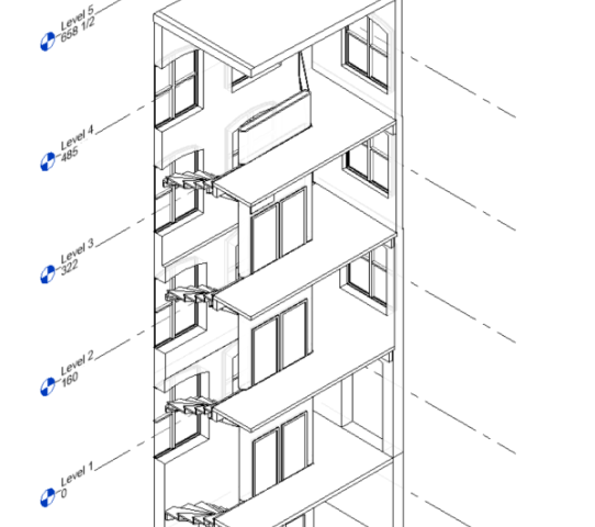
Receive Revit models, CAD drawings, and shareable point clouds tailored to your project workflow.
Easily share and review scan data with your team using Cintoo Cloud, ensuring alignment from anywhere.
Our laser scanning services provide up-to-date, detailed 3D representations of your facility or site.
Say goodbye to outdated plans and unreliable tape measurements — start your next project with precise, current data that prevents costly errors.
We deliver BIM models and CAD drawings derived directly from our scans, ensuring that architects, engineers, and contractors are working from the same accurate dataset.
This alignment improves communication, reduces design conflicts, and keeps projects on schedule.
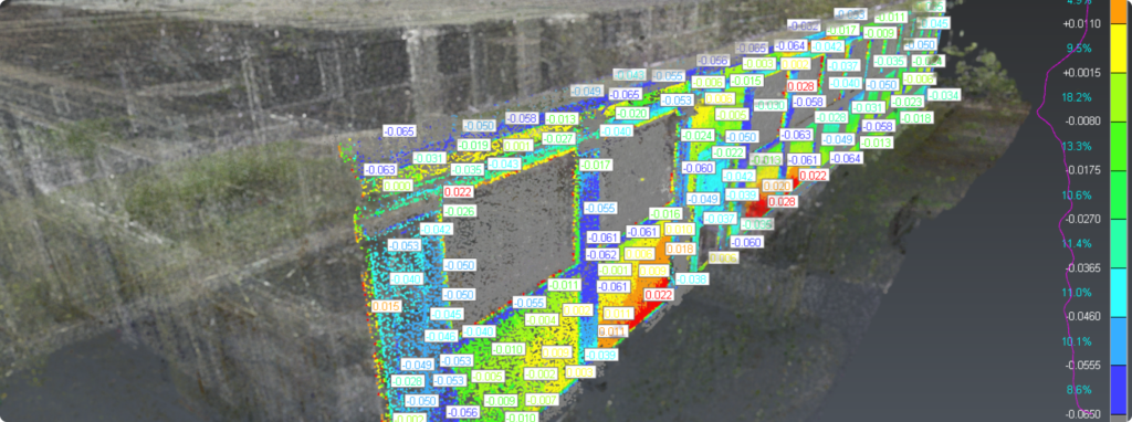
Through Construction Verification, we compare as-built scans to your original design model to detect deviations early.
This proactive approach saves time, reduces rework, and keeps your Vermont project moving forward confidently.
Access every detail of your facility remotely with our precise digital scans.
By replacing repeated field visits with accessible 3D models, you save time and resources while maintaining complete project accuracy.
Capture plants, breweries, and production spaces for accurate retrofit and expansion planning.
Document schools and universities to support campus renovations and modernization.
Provide verified as-built conditions for office, retail, and mixed-use developments
Capture bridges, treatment plants, and municipal assets across Vermont for maintenance and design planning.
Digitally document historic structures and town centers in Vermont’s older communities for restoration and compliance.
Monitor progress and validate installation accuracy on active jobsites.
Our seasoned experts and refined workflows capture every detail to accelerate decisions, reduce rework, and deliver successful projects on time and on budget.
Customized outputs tailored to your workflow – saving time and ensuring every stakeholder has exactly the data they need.
Reality capture isn’t one-size-fits-all. At OAR, we tailor data formats and workflows to your systems—ensuring you can instantly use and benefit from our precise deliverables.
From historical preservation and antique boat documentation to major industrial retrofits and port expansions, OAR has earned the trust of leading organizations by consistently delivering accurate, actionable laser scanning services.

Curious about how OAR can revolutionize your project? Explore our work.

Senior Integrations Designer, Waste Management Engineering Department
OAR’s team has been great to work with throughout multiple large-scale scan to BIM projects. High attention to detail, accurate scan data, proper BIM implementation and consistent communication/support from OAR has helped to improve our project quality and efficiency from start to finish.
I hired OAR to do a pre-construction scan to point cloud mesh and 2D CAD of my new building. I am glad I did… with Jon and Ryan this business goes above and beyond
Owner, TBJ Gourmet Food Manufacturing Plant
OAR attacks their projects methodically & professionally asking detailed questions regarding our final needs to fabricate. End result was a spectacular fit of formed powder coated aluminum angle under our cable guardrail system. Can’t wait to work with OAR on the next project!
President, Multi-Weld Services INC.
At OAR, we help Vermont architects, contractors, construction firms, and building owners transform complex sites into accurate, reliable 3D models. Whether you’re renovating a historic property or planning a new industrial facility, our laser scanning services give you the precision and confidence to move forward without guesswork.
Ready to take the next step?
You’ve read about us, and now we’d love to hear about you. Reach out today, and let’s talk about accelerating design and construction together.