Laser Scanning & BIM Coordination for Industrial Owners & Operators
Industrial facilities present unique challenges. Equipment is expensive, production schedules have zero tolerance for extended shutdowns, and the gap between what the drawings show and how the plant exists today can be significant. OAR provides 3D Laser Scanning, BIM Coordination & Virtual Construction, and Digital Delivery & Implementation services that work in active industrial environments and deliver verified data for retrofit coordination, capital project planning, and shutdown execution.
OAR serves industrial facility owners and operators across the Northeast: Connecticut, Massachusetts, Maine, New Hampshire, New York, Rhode Island, and Vermont. BIM Coordination and Digital Delivery & Implementation are delivered remotely nationwide.
Document your facility. Plan your upgrades. Execute with precision.

Accurate Documentation of What Actually Exists
Plan the Outage Before the Clock Starts
Every System Coordinated in Confined Space
A Digital Record That Outlasts the Project
Accurate Documentation of What Actually Exists
Industrial facilities change over decades of modifications, equipment swaps, and undocumented upgrades. The P&IDs say one thing. The field says another.
We capture the current state of your plant with laser scanning and deliver verified models that reflect what is actually installed, not what the original drawings show.
Plan the Outage Before the Clock Starts
The cost of a shutdown is not just the construction work. It is the production you lose while the line is down. When your turnaround planning is built from verified 3D geometry, your team sequences the work, identifies clearance conflicts, and locks down tie-in points before the outage window opens. The planning happens in the model. The execution happens on schedule.
Every System Coordinated in Confined Space
Industrial retrofits do not happen in open floor plans. They happen around live process systems, inside pipe racks, above operating equipment, and in spaces where every inch of clearance matters.
We coordinate mechanical, electrical, structural, process piping, and fire protection in the model so your trades are not solving spatial conflicts in hazardous or confined environments.
A Digital Record That Outlasts the Project
The scan data and coordinated models from your project become the baseline documentation for future operations, maintenance planning, and capital projects.
One capture serves the project today and the facility for years to come.
Three services. One partner.
Non-Intrusive 3D Laser Scanning in Active Facilities
Verified existing conditions without stopping the line.
OAR’s 3D Laser Scanning is performed in active industrial environments without disrupting production. Our team works during operating hours, overnight, or in scheduled access windows based on your facility’s requirements. The result is a verified point cloud of existing equipment, structural steel, utilities, and spatial constraints.
As-Built Documentation & BIM Coordination
Conflicts identified before construction begins.
OAR converts point cloud data into coordination models and manages clash detection for capital projects and retrofits. We coordinate new systems and equipment against verified existing conditions, identify conflicts before work begins, and document resolution in a format your project team can act on.
Digital Delivery for Long-Term Facility Intelligence
Your data keeps working after the project closes.
OAR’s deliverables extend beyond the immediate project. Point clouds, as-built Revit models, and coordination data become a long-term asset for your facility management team, available as a reference for future capital projects, maintenance planning, and operational decisions.
Industrial sectors we work in
Existing conditions capture and equipment coordination for manufacturing plants and food production facilities where production continuity is non-negotiable.
Fast scanning and BIM coordination for MRF and waste processing facilities undergoing equipment installations, conveyor reconfigurations, or capacity expansions.
Millimeter-accurate existing conditions for pharmaceutical and life sciences production environments with strict clearance requirements and complex MEP infrastructure.
Existing conditions capture and coordination for data center construction, expansion, and infrastructure upgrades where precision and schedule compliance are critical.
As-built documentation and coordination for chemical and processing plants with complex piping, equipment, and utility systems that require verified existing conditions before any capital work begins.
Facility documentation and coordination for distribution center expansions, conveyor system installations, and equipment integrations in active logistics operations.
Verified data for every phase of your capital project
High-density point cloud data captured during active operations. Delivered in .RCP, .RCS, or .E57 format. Compatible with Revit, Navisworks, AutoCAD, and all major engineering platforms.
LOD 300 Revit models reflecting verified existing conditions: equipment locations, structural steel, utilities, and spatial constraints. The foundation for all capital project engineering and coordination.
Every conflict between new equipment and existing facility conditions identified, documented, and tracked before fabrication and installation begin.
OAR stays engaged through installation and commissioning, providing field verification and model updates as work progresses.
A verified digital record of the facility accessible for future capital projects, maintenance planning, and operational decisions without requiring additional site visits.
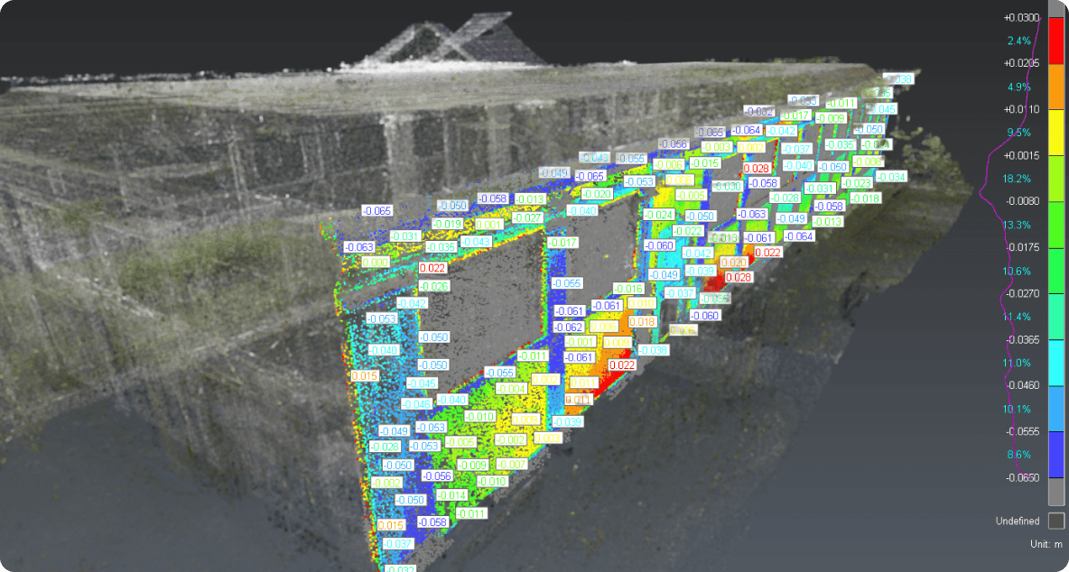
Laser scanning and BIM coordination in an active industrial facility.
Large-Scale MRF Optical Sorter Installation
California · Active Single-Stream MRF · Equipment Integration
Facility scanned in active operations
Spatial conflicts identified before fabrication
Field conflicts at installation
An active single-stream materials recovery facility needed to install a new optical sorter into existing overhead structure without disrupting ongoing operations. OAR performed non-intrusive weekend scanning, delivered a LOD 300 Revit model, and ran clash detection against the new equipment model. All 27 conflicts were resolved before fabrication began. The equipment was installed without a single field conflict.
From the field.
Posted on Google
 Maxwell Capon
Trustindex verifies that the original source of the review is Google.
Jon and his team were great! Very response and the deliverables were exactly what we needed!Posted on Google Chris HerrmannI hired OAR to scan a 14,000 mixed-use retail and office building that I purchased and needed a solid set of 2D drawings of. This proved to be a cost effective way to get those, plus SOOO much more. The level of detail they produced is exceptional and will save time and cost for many years to come. They did what they said they were going to, were very accommodating of tenants in an existing and fully occupied building, and were great to work with in general. I would highly recommend them to anyone with a similar need.Posted on Google
 eturbo924OAR has proven to be an exceptional partner that has truly revolutionized our operations. We've had the pleasure of collaborating with Ryan and his team, and their expertise has been pivotal in addressing complex challenges related to software interoperability, design enhancement, and workflow streamlining. The transition from conventional 2D design to the dynamic world of 3D and BIM was made possible and seamless through OAR's unparalleled contributions. One of the standout features of OAR's service is their remarkable scan-to-BIM capability. The precision and accuracy with which they transform real-world scans into comprehensive BIM models is nothing short of remarkable. This aspect alone has elevated the quality of our projects to new heights, enabling us to work with existing conditions in ways we hadn't imagined before. What truly sets OAR apart is not only their exceptional technology, but also their unwavering commitment to delivering excellence. Their service is a true testament to their dedication, as they consistently ensure that the systems we rely on day in and day out operate flawlessly. This level of reliability has undoubtedly accelerated our project timelines, allowing us to make informed decisions based on a newfound depth of existing conditions data. Having partnered with OAR for the past two years, it's clear that they've become an indispensable asset to our success. Their impact on our projects is undeniable, and the transformational journey from our initial engagement to the present day has been nothing short of remarkable. As a small business, OAR's dedication, innovation, and exceptional service have proven that size is no measure of capability. In light of our extraordinary experience, I wholeheartedly recommend OAR without reservation. If you're seeking to leverage the power of laser scanning and BIM, there's simply no better choice. OAR's expertise, passion, and commitment to excellence make them the first and only call you need to make. They don't just deliver a service; they deliver a transformative partnership that propels your projects to unprecedented levels of success.Posted on Google
 Mike OraschewskyProfessional, timely and highly accurate scanning and modeling by OAR has saved me $$$. Having a single 3D source of truth for engineers, OEMs and tradesmen made my last project a breeze.Posted on Google
 Mike OraschewskyI hired OAR to do a pre-construction scan to point cloud mesh and 2D CAD of my new building. I am glad I did: the integrations engineer, GC, subs, and equipment manufacturers (most of whom are overseas) are delighted to have the ability to step into the space and confirm fit and plan my construction intelligently based on onsite conditions. Most importantly - with Jon and Ryan this business goes above and beyond. I had concerns my design/construction group wouldn’t use what OAR provided but Ryan and Jon took the time after they delivered the point cloud and drawings to show my team how to use this tool to make sure it saves my team’s time and by extension: my money in construction. We are making last minute design changes now that if not identified would’ve cost 5 figures $. This technology is exciting to use as a project owner. I’m considering having them back out for an as-built once construction completes. And I’ll always have them do a pre construction scan on any factualities I buy going forward. Thank you OAR.Posted on Google
 Jean-philip GiguèreFast, precise and affordable. They greatly simplify difficult tasks!Posted on Google
 Alex QuarterleyOAR's team has been great to work with throughout multiple large scale scan to BIM projects. High attention to detail, accurate scan data, proper BIM implementation and consistent communication/support from OAR has helped to improve our project quality and efficiency from start to finish.
Frequently asked questions
Yes. OAR is experienced in non-intrusive scanning in active manufacturing, processing, and industrial environments. We coordinate access with your facility team and work during operating hours, overnight, or in scheduled windows to eliminate production impact.
OAR’s laser scanning captures existing conditions within plus or minus 3mm at standard scanning distances. This level of accuracy is sufficient for capital equipment installation planning, clash detection, and engineering design, and significantly exceeds manual field measurement accuracy.
As-built documentation is a verified record of your facility as it currently exists, including equipment locations, structural elements, utility routing, and spatial constraints. Industrial facilities accumulate changes over years of operation that rarely make it back to the original drawings. As-built data gives your engineering and project planning teams a reliable foundation for capital projects.
OAR works with manufacturing facilities, food and beverage production, pharmaceutical and life sciences, materials recovery facilities, data centers, distribution centers, and processing plants. Our non-intrusive scanning approach is suited to any environment where production continuity is a priority.
Yes. OAR provides BIM Coordination & Virtual Construction services for equipment installation projects, including clash detection, coordination model management, and conflict resolution documentation. We can serve as the full coordination partner or as the scanning and modeling resource supporting your internal team.
Laser scanning captures verified 3D geometry of your facility before the outage window opens. Your planning team uses the data to sequence work, identify clearance conflicts, verify tie-in points, and plan rigging paths against actual conditions, not outdated drawings. When the shutdown starts, your crew executes from a plan built on real measurements.
When properly structured, scan data and coordinated models become a long-term digital record for your facility. OAR delivers with consistent naming, metadata, and coordinate systems so the data is findable and reusable for future capital projects, maintenance planning, and operational decisions without requiring a new scan.