
Old Port Marina Site Documentation: Drone Photogrammetry & Terrestrials SLAM Data Across a Floating Dock & Waterfront Site.
The Project
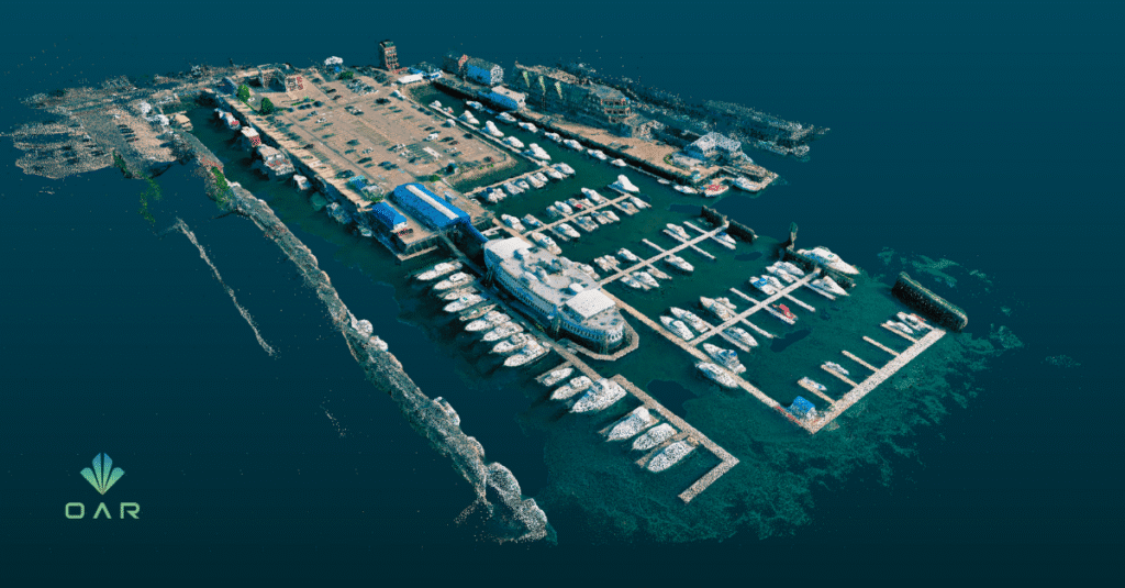
The client partnered with OAR to complete a Scan-to-BIM survey of the Old Port Marina in Portland, Maine. The goal was to capture the existing floating docks and integrate pile condition data into a geolocated 3D model. The as-built package now supports permitting, reconstruction planning, pile replacement, and future utility installations.
No existing plans. A structure that moves. Airspace that isn't open.
The marina had no existing 2D or 3D plans to work from. Floating docks are difficult to scan with traditional fixed-position equipment because the structures shift with tide and load. Aerial capture required FAA clearance for controlled airspace near the waterfront. Dive-inspection data on pile condition also needed to be merged with the above-water BIM model, which meant coordinating two entirely different data sources into one deliverable.
Hybrid capture. One geolocated model.
Hybrid Reality Capture
OAR deployed a hybrid capture strategy combining an RTK drone for aerial data and planimetric positioning with a BLK2GO scanner for agile scanning across the floating docks. GPS integration tied every scan to municipal property lines, giving the model a verified real-world reference frame from the start.
Point Cloud Processing & Geolocation
The point cloud was processed into a geolocated 3D Revit model, with utility corridors coordinated for future electrical and fuel line installations.
Dive Data Integration & Pile Tagging
OAR integrated dive-inspection data by tagging individual piles with metadata, including degradation level and wall thickness, directly inside the model. This merged the above-water BIM with below-water condition data into a single reference for engineers.
Six docks mapped to quarter-inch accuracy in a single tide window.
The project delivered a digital twin of the marina, giving the engineers remote access to accurate, high-resolution data. Engineers could assess pile conditions without returning to the site, align future utility work with confidence, and extract scheduling data directly from the model. The deliverables streamline permitting, planning, and design while reducing risk and uncertainty on a site with no prior documentation.
Geolocated 3D Revit model — full floating dock system tied to municipal property lines
Registered point cloud — hybrid drone and mobile LiDAR capture
Pile condition metadata — dive-inspection data tagged by degradation level and wall thickness
Coordinated utility corridors — planned routing for future electrical and fuel lines